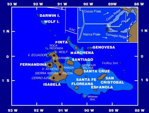
This map is more complex than the previous (simple map) and it has a lot of useful
information. We can clearly see the latitude and longitude, without the lines obscuring the image. Major
islands are labelled in bold type and smaller ones are also labelled. Note that names of Isabela's volcanoes
are included (italics). The two features labelled Fitzroy Smt. and Whitmer Smt. refer to
underwater seamounts that may once have been above sealevel but either eroded away or subsided due to
tectonic activities. The major tectonic plates and their relative motions (white arrows) are shown in the
inset diagram which also shows the islands' relative distance from the mainland.
(Map courtesy of Cornell Geology)
|


