Latitude and longitude come from simple spherical geometry.
What is latitude?
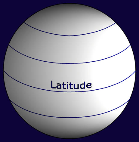
A line of latitude or Line of
Parallel is an imaginary line around the earth that runs parallel
to the equator. It shows in degrees (º) how far north
or south a place is. The latitude of 0 degrees is on the equator
an imaginary line on the earth's surface. The equator divides
the earth into the Northern Hemisphere and Southern Hemisphere
(from Greek hemi half). The equator line passes
through the northern part of Isabela, the biggest island in Galapagos.
Look at a map of the world to see the other places though which
the equator passes. The angle between the equator and the poles
is 90 degrees so the Poles are at 90 degrees north or south. The
farthest north or south you can go is 90 degrees, which puts you
on the North or South Pole.
What is longitude?
A line of Longitude shows distance
in degrees you are east or west from a special line that joins
the north and South Pole. The world turns west to east (anticlockwise
from above). So defining a 0 line is more arbitrary than for latitude
hence, the Greenwich Meridian and Greenwich Mean Time had
to be created. To make lines of longitude, slice through the earth
at the equator where you'll make a horizontal circle. Divide the
edge of this horizontal circle into two sets of 180 degrees (East
or West). The 0 degree line passes through Greenwich to make the
Greenwich Meridian. Next, make imaginary lines north and south
from the equator that they converge on each pole. Now you have
the meridians or lines of Longitude.
In the 18th century England was the world's greatest sea power and had a large Navy. The country had the most technologically advanced observatory in the world. Observatories are special laboratories for studying meteorology and astronomy. When maritime nations gathered to choose the special north-south line they decided the line should run though the main telescope of the Royal Greenwich Observatory. Ever since that meeting, mapmakers have the 0 degree Longitude Meridian running through Greenwich, England in London. This also explains why all the world's time zones are relative to Greenwich Mean Time (GMT).
(Reproduced with permission. Instituto Geografico Militar, Quito, Ecuador)
![]()
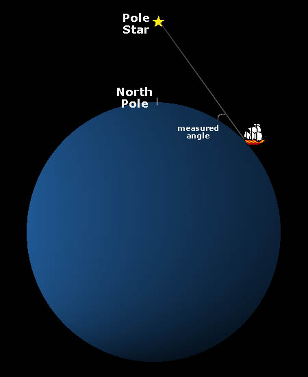
This diagram shows how early navigators used the Pole Star to find how far north they were how close to the North Pole. They would measure the angle to the Pole Star. You can see that when the ship moves northwards, the angle between the line to the Pole Star and the Earth's surface increases. Thus, the change in the angle would tell the navigator the ship's position relative to the North Pole. Read on for more explanations of navigation.
Navigation is the science of position-finding and charting a safe course. The two numbers, latitude and longitude, used together, give the positio, in degrees, anywhere on Earth. Latitude tells how far north or south of the equator a place is, and longitude tells how far it is east or west of the Greenwich meridian. Because one degree equals about 60 nautical miles distance, the two numbers make a square 60 miles wide and 60 miles long (one nautical mile =1.15 land miles). For greater accuracy, each degree is divided up into to 60 minutes. A shorthand for sixty minutes is written 60'. This defines an area one mile by one mile at the equator. For yet more precision each minute latitude or longitude is further divided into 60 seconds. One second is about 34 yards. A shorthand for sixty seconds is written 60". To navigate successfully you need to find your position (degrees, minutes and preferable seconds) for both latitude and longitude. Modern Global Position Satellite (GPS) systems are accurate to a few yards, a few seconds longitude and latitude. But what did navigators do before then?
Finding latitude
At the surface, these lines of latitude
are parallel to the equator. It's a simple matter to find
out which line of latitude (how far north or south) that you are
on. To find you latitude you measure the angle between the horizon
and a reference point in the sky marking the pole beneath. An
instrument called a sextant is used to measure the angle accurately.
In the Northern Hemisphere a bright star is almost directly above
the North Pole. This so-called "Pole Star" made navigation
easier for early mariners. They simply sailed along a line of
latitude east or west to get most of the way to where they wanted
and then finished their journey by sailing directly north
or south. It's harder in the Southern Hemisphere because there
is no convenient star. There you have to find a similar point
in the sky above the South Pole but the idea is the same.
Finding longitude
It's much harder to find where you
are east or west. Before the invention of Global Position Satellites
(GPS) and sophisticated navigation techniques, it was very hard
to know on which line of longitude you were. There are no convenient
signposts in the sky. Like the sun, the stars seem to move. The
usual method used by mariners before reliable clocks were made
was to throw a "Log Line" overboard to measure the ship's
speed. If the speed was known navigators used "dead reckoning"
to calculate their position (though the calculation basically
was a clever guess). Errors over long sea-voyages could soon amount
to hundreds of miles. Ships were wrecked on unknown coasts as
a result of navigation errors. Because of these errors, in the
18th century England's Admiralty offered a huge reward for a reliable
clock that could be used at sea. At the equator, an error of one
minute in the time on a clock (or chronometer as marine clocks
were known) makes an error of 60 nautical miles from the expected
position.
To calculate longitude you need to know the angle of the sun and the time of day relative to a set location, usually the Greenwich Meridian. An instrument called a sextant is used to measure the sun's angle. Again, Navigation Tables are used. It is essential to know the exact time the observation is made. An error of one minute in time will result in an error on the equator of 60 nautical miles.
The task to find the position on a line of longitude is made even more difficult of course, because of the earth's daily rotation on its axis and the distance the ship has traveled. However, with an accurate clock you can calculate out how far east or west of Greenwich (0º) you are.
Around 1000 AD early Viking voyagers could position themselves on a line of latitude using a simple sextant to measure the angle between the horizon and Pole Star. This method was used by the Vikings to discover Greenland and Newfoundland. About 750 years later John Harrison invented a clock accurate to half a minute over a year. Navigators were now able to calculate longitude accurately. Before modern clocks, it was very difficult to keep accurate time. John Harrison's precision clocks he called "chronometers", were able to withstand a sea voyage. These were a technological breakthrough. That is why before the 18th century there were so many shipwrecks navigators could be hundreds of miles away from where they thought and sail the ship right on to a reef. It also explains why maps before then were woefully inaccurate.
At last, navigators could find their exact position: they knew their latitude and they knew their longitude. Where those lines crossed on their maps (known as 'charts' at sea) was their precise position on the surface of the earth.
![]()