18TH CENTURY MAPS
Here is a collection of small 18th century (1700s) maps from atlases and travelogues. The 1700s, during the
height of the Age of Reason, were a golden age in map-making. During this century, global exploration increased
dramatically in part due to the invention of accurate chronometers (clocks) that improved the ability of
navigators to determine longitude — how far east or west you are. From being a backwater refuge for
buccaneers to hide from the Spanish, the Galapagos Islands became an essential stopover for whalers who were now
exploiting the eastern Pacific as catches in the Atlantic had begun to decline. In particular pay attention to
how the detail of the maps improved from the early part of the century to later.
|
Click below to see the image and information on the 18th century maps:
Moll 1711
Sayer 1775
Reid 1796
MOLL 1711 MAP
Click image to return to gallery
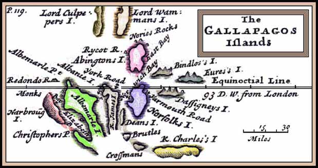
Dutch cartographer, Herman Moll (d. 1732) based this 1711 map on those drawn by English buccaneer Captain William Cowley who visited the islands in 1684. Cowley named the islands after various English nobles, so beginning the confusion that has plagued mapmakers ever since (and, more recently, tourists!). This map is an improvement on earlier versions made in the 1690s. Moll's maps were in turn widely used by other map makers, such as Emanuel Bowen. An interesting feature of the above map is that all the islands are shown much closer than in reality. "King Charles's Island" (San Cristobal) appears about 20 miles from "Norfolks Island" (Santa Cruz) whereas the true distance is about 50 miles. This particular inaccuracy persisted up until the Admiralty charts produced in the mid-19th century. Moll later revised his chart, producing a better version in 1726. This map was part of a Map of South America, According to the Newest and most Exact Observations. It was dedicated to Charles, the Earl of Sunderland, and Baron Spencer of Wormleighton. |
SAYER 1775 MAP
Click here to return to old maps gallery
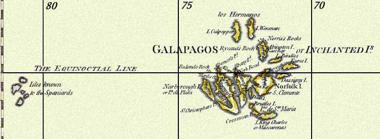
Robert Sayer (1725-1794) was first to label the Galapagos on a map as the "Enchanted" which had a different meaning then than now. Tour companies like to use the name to mean "delightful" but the original meaning was "bewitched", perhaps because strong currents made navigation so difficult that sailors sometimes had to wait for days before they could make landfall. This 1775 map is part of a much larger chart: A Map of South America Containing Tierra-Firma, Guayana, New Granada, Amazonia, Brasil, Peru, Paraguay, Chaco, Tucuman, Chili and Patagonia. Curiously, the group of "Isles known to the Spaniards" although appearing on many maps of the time, does not exist, although it may represent the Marquesas Islands some 3000 miles to the west. |
REID 1796 MAP
Click here to return to old maps gallery
John Reid was an American (New York) map publisher who in 1796 produced A General Map of South America From the Best Surveys. This included the Galapagos at the exact correct longitude (90 W)—a result of the accurate chronometers invented in the mid-1700s. These later maps are an improvement on Moll's map (above). The southern portion of Albemarle (Isabela) and James (Santiago) are closed and the islands are farther apart. However, the "Is. said to be known to the Spaniards" are still there; an error that disappears from later maps. |
Learn more about the 18th century maps
previous maps
|
next map
|
|---|


