HYDROLOGY MAPS
Hydrology is a branch of geology that studies the distribution, uses and conservation of water on the earth and in the atmosphere.
Consider that the Amazon holds a fifth of the world's fresh water, and it makes sense that hydrology is essential to
understanding the large-scale structure and function of its ecosystems. |
Click below to see the maps and information on the hydrology maps
river network
rainfall
evapotranspiration
RIVER NETWORK MAP
return to gallery
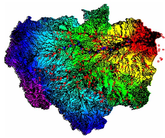
This map shows the network of natural waterways that drain the Brazilian portion of the Amazon River basin (other countries not shown). The rainbow colors indicate the distance from the river's mouth to the east (right). The width of the rivers is exaggerated to give an idea of the density of rivers within the basin. |
RAINFALL MAP
return to gallery
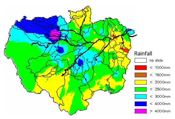
This color-coded map indicates rainfall intensity throughout the Brazilian portion of the Amazon basin. Look for the areas of highest and lowest rainfall. |
EVAPOTRANSPIRATION MAP
return to gallery
Evapotranspiration is the total amount of water transferred to the atmosphere from the earth's surface. It includes water evaporates plus the amount that transpires from plants. Note the areas of highest and lowest transpiration. Why do you think there are differences from one region to the next? How does this compare with the map of rainfall? Why don't the areas of highest rainfall correspond with the areas of highest evapotranspiration? |
Learn more about the hydrology map
previous maps
|
next section
|
|---|


