EL NINO SATELLITE IMAGE AND MODEL
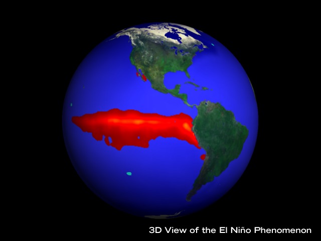
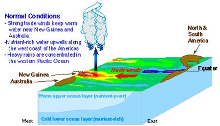
El Niño is the name given to a cyclic weather pattern that has dramatic effects throughout the Pacific region and beyond. It tends to begin around Christmas and was named by Spanish-speaking fishermen after Jesus (The Child = El Niño in Spanish). The first image below shows the distribution of sea temperatures in the equatorial east Pacific Ocean, and the diagrams explain how the pattern arises. In the Galapagos Islands, the main climatic effects are increased sea temperatures and heavier than normal rainfall. (See climate charts.) |
Click below to see the El Nino satellite image and model information:
El Nino satellite image
El Nino model
EL NINO SATELLITE IMAGE
Click image to return to gallery
This is a false-color enhanced image that shows the sea temperatures in the eastern Pacific around Christmas. The red area indicates increased surface water temperatures. The current along the west coast of South America, through to the equatorial Pacific, is warmer than surrounding waters and the Galapagos Islands are directly in line, and are bathed by warm water (see Ocean Currents Map). This phenomenon has profound effects on the plant and animal life of the Galapagos Islands. Rainfall increases, promoting the growth of land plants thus interfering with the breeding of sea birds that rely on open areas to lay eggs. On the other hand, land birds thrive with the increase of seeds and insects. Due to the increase in sea temperatures, and reduction of upwelling (rising of nutrients from the seafloor), marine life is reduced so animals that depend on the sea for food suffer high mortality from starvation. (For records of rainfall in an El Niño year see Weather chart.) |
EL NINO MODEL
Move your mouse over the diagram to compare El Niño and normal conditions
Click image to return to gallery
Normal weather conditions in the Pacific Ocean feature strong westerly trade winds, keeping waters off the coast eastern Australia and New Guinea warm, and maintaining deep water upwelling off the western coast of South America. During El Nino events, the trade winds weaken, and warm water moves eastward, upwelling is diminished and rainfall increased in the East Pacific. |
Learn more about El Nino
previous image
|
next image
|
|---|


